Drone App: Forecast for UAV
Go Dreams
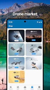
Screenshots
editor reviews
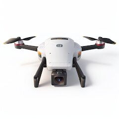
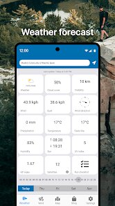
As someone who flies drones both for work and recreation, I've always struggled with weather unpredictability. Nothing ruins a shoot faster than unexpected wind gusts or sudden rain. That's exactly the problem Drone App: Forecast for UAV by Go Dreams sets out to solve. It's a specialized weather forecasting tool built specifically for drone pilots, providing hyper-local, aviation-grade meteorological data that goes far beyond what standard weather apps offer. Instead of generic conditions for a city, this app gives you wind speeds at specific altitudes, precipitation probabilities, visibility, and even satellite navigation interference levels. It essentially acts as a knowledgeable co-pilot who checks the skies for you.
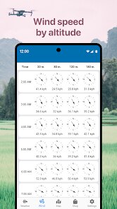
For anyone who flies drones, this app addresses a very real pain point: the anxiety of taking off without knowing exactly what the next 20 minutes holds. The core features work remarkably well. I found the hourly wind forecasts up to 120 meters to be incredibly accurate—spot on compared to what my aircraft's telemetry showed. The app doesn't just tell you “windy” or “calm”; it shows the specific KTS (knots) per altitude layer, which is the gold standard for safe flying. I personally used it to plan a critical real estate fly-over that had a very tight window. The app predicted a lull in the wind at 60 meters between 3:00 and 3:30 PM, and it was exactly right. I got the shot, and my footage was butter smooth.
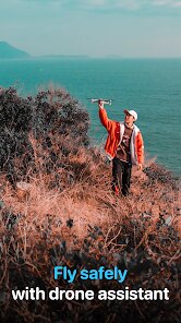
That said, this app is not for the casual toy drone user who flies on sunny weekends without a care. It's built for the serious operator—someone using a DJI, Autel, or other professional-grade UAV for mapping, inspection, cinematography, or agriculture. If you're wondering how to avoid flying into a micro-burst or want to know if you have a solid 30-minute window to capture sunset footage, this tool is worth every cent. It shines brightest for pre-flight planning in unpredictable coastal, mountainous, or urban environments where conditions shift quickly. I would recommend it to any commercial pilot or dedicated hobbyist who treats their flights with the seriousness they deserve.
features
- 🛩️ Altitude-Based Wind Forecasting: You can view wind speed and direction from ground level all the way up to 120 meters (about 400 feet). This is broken down in 10-meter increments, which is a game changer for understanding what your drone will actually experience at flying height, not just what the ground feels like.
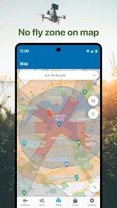
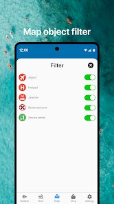
- 🌧️ Precipitation & Visibility Radar: The app pulls in live radar data to show rain, snow, and fog intensity. It highlights “flyable” vs. “unflyable” conditions with color-coded markers, so you instantly know if you need to scrub the flight or keep going.
- 🧭 Kp Index & GPS Interference: A feature many drone pilots overlook is the Kp index—a measure of geomagnetic activity. This app displays it clearly, warning you when solar activity might mess with your GPS lock or compass calibration. It saved me from a potential flyaway on a high-index day.
- 📱 Clean Dashboard & Flight Logging: The interface isn't cluttered with irrelevant data. You get a clean, professional dashboard with a “Good to Fly” score. Plus, you can log your flight conditions, which is excellent for insurance or client records later.
pros
- ✅ Hyper-Local Accuracy: Unlike generic apps, this one uses weather models specifically calibrated for low-altitude aviation. The predictions are noticeably more precise for drone flight altitudes.
- ✅ Saves Time & Money: By preventing aborted launches or lost shoots due to unexpected weather, this app pays for itself after just one or two successful missions.
- ✅ No Unnecessary Fluff: It sticks to what matters for UAV pilots. There are no ads for tropical vacations or irrelevant news headlines—just clean, actionable data.
cons
- ❌ Limited Global Coverage: The app works great in North America and much of Europe, but coverage in remote or developing regions can be patchy or unavailable.
- ❌ NOt Great for Beginners: The data richness can be overwhelming if you don't understand what Kp index or “gust ratio” means. A short in-app guide or glossary would help new users a lot.
- ❌ Battery Drain: Constant GPS and data polling drains your phone battery significantly faster than standard weather apps. Definitely keep a power bank handy on longer field days.
Recommended Apps
![]()
Webex Meetings
Cisco Systems, Inc.4.5

![]()
Love Detector - Fingerprints
KOSHINA APPS0![]()
Persona: Beauty Camera
TICKET TO THE MOON, INC.4.5![]()
AI Kiss & Hug Video - DreamVid
Shenzhen iMyfone Technology Co., Ltd.4.4![]()
Text Free: Call & Texting App
Pinger, Inc4.4![]()
CapCut - Video Editor
Bytedance Pte. Ltd.4![]()
Duolingo: Language & Chess
Duolingo4.7![]()
ChatBot - AI Chat
X PhotoKit4.5![]()
McDonald's
McDonalds USA, LLC4.6![]()
Idol Prank Call: Fun Video
EPIKMOUNT JOINT STOCK COMPANY3.9![]()
Air Horn Prank (Loud Joke)
RRM Jokes, Pranks and fun apps4![]()
Monster High Fangtastic Life
Budge Studios4.1![]()
StyleLab: AI Clothes Try On
IRONTECH4.2![]()
Home Design 3D
Anuman4.3![]()
Cash App
Block, Inc.4.6


Hot Apps
-
![]()
Google Pay
Google LLC4.4 -
![]()
Ford™
Ford Motor Co.4.7 -
![]()
OfferUp: Buy. Sell. Letgo.
OfferUp Inc.4.4 -
![]()
Pandora - Music & Podcasts
Pandora4.1 -
![]()
Perplexity - Ask Anything
PerplexityAI4.7 -
![]()
Spotify: Music and Podcasts
Spotify AB4.3 -
![]()
Afterpay - Buy Now Pay Later
Afterpay3.8 -
![]()
Direct Express®
i2c Inc.4.3 -
![]()
Facebook
Meta Platforms, Inc.4 -
![]()
Amazon Fire TV
Amazon Mobile LLC4.1 -
![]()
Telegram
Telegram FZ-LLC4.1 -
![]()
Klarna | Shop now. Pay later.
Klarna Bank AB (publ)4.3 -
![]()
Chai: Chat AI Platform
Chai Research Corp.4.3 -
![]()
Google Gemini
Google LLC4.6 -
![]()
SiriusXM: Music, Sports & News
Sirius XM Radio Inc4.8 -
![]()
Zoom - One Platform to Connect
zoom.us4.1 -
![]()
Duolingo: Language & Chess
Duolingo4.7 -
![]()
Amazon Alexa
Amazon Mobile LLC4.5 -
![]()
ChatGPT
OpenAI4.8 -
![]()
CapCut - Video Editor
Bytedance Pte. Ltd.4 -
![]()
DoorDash - Food Delivery
DoorDash4.6 -
![]()
Affirm: Buy now, pay over time
Affirm, Inc4.7 -
![]()
Google Home
Google LLC4.2 -
![]()
GroupMe
GroupMe4.5 -
![]()
Google Maps
Google LLC4.2 -
![]()
Uber Eats: Food Delivery
Uber Technologies, Inc.4.6 -
![]()
PolyBuzz: Chat with AI Friends
CLOUD WHALE INTERACTIVE TECHNOLOGY LLC.3.8 -
![]()
Venmo
PayPal, Inc.4.2 -
![]()
Cash App
Block, Inc.4.6 -
![]()
Signal Private Messenger
Signal Foundation4.5


Disclaimer
1.Apkspack does not represent any developer, nor is it the developer of any App or game.
2.Apkspack provide custom reviews of Apps written by our own reviewers, and detailed information of these Apps, such as developer contacts, ratings and screenshots.
3. All trademarks, registered trademarks, product names and company names or logos appearing on the site are the property of their respective owners.
4.Apkspack abides by the federal Digital Millennium Copyright Act (DMCA) by responding to notices of alleged infringement that complies with the DMCA and other applicable laws.
5.If you are the owner or copyright representative and want to delete your information, please contact us [email protected].
6.All the information on this website is strictly observed all the terms and conditions of Google Ads Advertising policies and Google Unwanted Software policy.
7.Apkspack.com is an independent, information-only website which is 100% free to all the users.